
Lagoon and coastal pools heritage upgrade works
Tuesday, 26 May, 2020
Northern Beaches Council engaged ELA to undertake the required heritage technical studies as part of numerous projects concerning both minor and major routine maintenance works to heritage items within the Local Government Area (LGA).
Read More
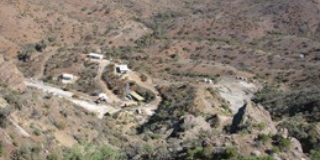
Clydesdale Estate Heritage Advice, S60 Application and Excavation
Tuesday, 26 May, 2020
ELA prepared historical archaeological assessment and formulation of archaeological management policy for a large, State heritage listed property and preparation of multiple S60 applications to the Heritage Council for bulk earthworks, adaptive reuse of heritage listed buildings and archaeological excavation.
Read More
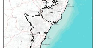
Critical Habitat Mapping in Northern & Coastal New South Wales
Tuesday, 26 May, 2020
The World Wide Fund for Nature-Australia (WWF-Australia) contracted Eco Logical Australia (ELA) to create a comprehensive set of spatial datasets of biodiversity sensitivities and conservation values of coastal New South Wales. This map would summarize all values to create a unified critical habitat map for use in conservation projects.
Read More
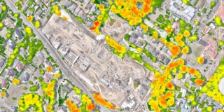
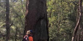
Cherrybrook Tree Canopy Audit
Tuesday, 26 May, 2020
The Cherrybrook Station Precinct, located in Sydney metropolitan area, contracted Eco Logical Australia (ELA) to conduct an audit of the makeup of the current tree canopy across the Precinct in order to meet the Draft Green Infrastructure Policy for NSW (Greener Places) initiative.
Read More
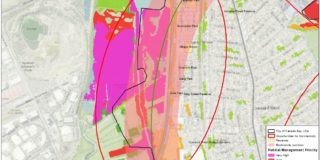
Biodiversity Framework and Action Plan
Tuesday, 26 May, 2020
The City of Canada Bay is located within the Sydney basin bioregion, along the Parramatta River foreshore. The City manages 245 ha of public open space in 169 parks and has 47 ha zoned for environmental conservation. Eco Logical Australia (ELA) created a Biodiversity Framework and Action Plan for the City to help to ensure local ecosystem health. Good ecosystem health ensures that the social, economic, environmental, and health services provided by the ecosystems will continue to provide their benefits for current and future generations.
Read More
Significant Tree Surveys
Monday, 25 May, 2020
Brisbane City Council (BCC) manages 9500 ha of natural areas for conservation and nature-based activities within the City. A critical component of this management is fire – applying the right frequencies and intensities is important to retain the essential structural and composition features of each vegetation type, and so that fire does not damage human assets and natural features such as large trees.
Read More
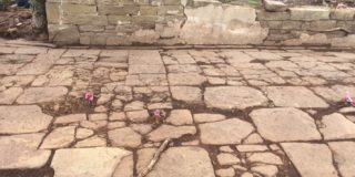
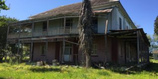
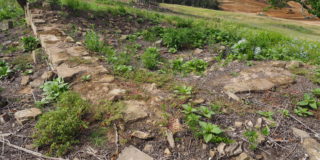
Archaeological Excavation Leppington House
Saturday, 9 May, 2020
In 1821 William Cordeaux was granted 700 acres which he named Leppington. His house and associated farm outbuildings, constructed with convict labour, were occupied for over 130 years as residence while the original land grant remained intact for almost 200 years.
Stockland are in the process of incorporating the Leppington House Archaeological Site into a heritage park, with the archaeological remains and park setting as a focal point for recreation activities for the community. Eco Logical Australia provided Stockland with all heritage and archaeological compliance for this project including:
Read More
Heritage Compliance for Willowdale Estate
Friday, 29 November, 2019
Eco Logical Australia has been involved in all aspects of heritage compliance for the Willowdale Estate development site for Stockland since 2016. This project comprised complex multi-stage residential development, retirement living and open spaces in association with the Denham Court Road bridge duplication. Eco Logical Australia provided approved built heritage, archaeological and Aboriginal heritage compliance for the project which included:
Read More
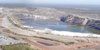
Mine Closure Plan (MCP)
Monday, 2 September, 2019
Eco Logical Australia have worked with Energy Resources of Australia to deliver a Mine Closure Plan (MCP) for Ranger Uranium Mine.
Read More
Programs for Environment Protection and Rehabilitation (PEPR)
Monday, 2 September, 2019
Eco Logical Australia has worked with Sibelco to write Programs for Environment Protection and Rehabilitation (PEPR) for their, Oraparinna Barite Mine and Mt Fitton Talc Mine.
Read More